San Pablo Avenue is a key corridor that links the Alameda County cities of Oakland, Emeryville, Berkeley, and Albany, as well as cities in western Contra Costa County. There is an urgent need for safety improvements along the corridor, which has the third highest rate of injury collisions in Alameda County. San Pablo Avenue also serves as the second busiest corridor for AC Transit bus riders. Alameda CTC is leading three complementary near-term project components to improve safety and transit along the San Pablo Avenue corridor. The three project components are:
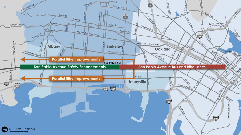
- Safety Enhancements Project (Berkeley and Albany). This project will improve the safety for pedestrians and bicyclists crossing San Pablo Avenue and improve transit speed by installing high visibility crosswalks, flashing beacons, pedestrian signals, median refuge islands, upgraded lighting, accessible curb ramp upgrades, bulb outs at Rapid bus stops, and bus stop relocations.
- Parallel Bike Improvements Project (Berkeley, Albany, and North Oakland). This project will implement improvements along bike boulevard/neighborhood bikeway routes that run along and connect to San Pablo Avenue, including traffic calming, crossing treatments at busy streets, and signage/wayfinding.
- Bus Lanes and Bike Lanes Project (Oakland, Emeryville, and South Berkeley). This project will improve transit speed and reliability by converting one vehicle travel lane in each direction to a dedicated bus lane and provide new cycling connections by converting parking lanes to protected bike lanes. The project will also include intersection safety improvements, bus stop consolidation, and new loading zones. Bus lanes and bike lanes are not currently proposed in Berkeley north of Heinz Ave.
Project Timeline
The three projects were identified as part of an extensive corridor planning effort between 2017 and 2020, in which we heard about the need for safety improvements to make walking, biking and taking the bus safer, and transit improvements to make buses faster and more reliable.- 2021-23: We developed concepts for the three near-term projects designed to achieve these goals. In March 2022, our Commission approved the project concepts to move into the design process.
- 2022-23: We solicited and received community feedback on Safety Enhancements and Parallel Bike Project designs. These two projects were then approved by the Berkeley and Albany City Councils.
- 2024: Draft plans for the Bus Lanes and Bike Lanes are ready for community input! We are conducting extensive public engagement in Oakland, Emeryville and South Berkeley to seek feedback.
Project Fact Sheets
- Safety Enhancements
- Parallel Bike Improvements
- Bus Lanes and Bike Lanes Project
Project Video
Safety Enhancements and Parallel Bike Concept Design Boards
- Handout
- Introduction Boards
- Segment 1: Brighton Avenue to Solano Avenue
- Segment 2: Buchanan Street to Harrison Street
- Segment 3: Gilman Street to Cedar Street
- Segment 4: Virginia Street to Allston Way
- Segment 5: Bancroft Way to Carleton Street
- Segment 6: Derby Street to Carrison Street
- Segment 7: Haskell Street to 63rd Street
- All Boards (large file)
Agency Board Presentations
- March 9, 2022: AC Transit
- March 14, 2022: Alameda CTC Planning, Policy and Legislation Committee (PPLC)
- March 15, 2022: Emeryville City Council
- June 28, 2022: Oakland Public Works Committee
- July 19, 2022: Oakland City Council
- May 25, 2023: Albany Transportation Commission
- July 17, 2023: Albany City Council
- July 20, 2023: Berkeley Transportation and Infrastructure Commission
- November 8, 2023: AC Transit Board
- November 14, 2023: Berkeley City Council
We are currently conducting community engagement on designs for the Bus Lanes and Bike Lanes Project in Oakland, Emeryville, and South Berkeley and we need your input! There are many opportunities to review design ideas and to provide your feedback, including:
- Interactive map survey
- OPEN HOUSES
- Monday, April 15, 2024, 6-8 p.m.
Golden Gate Recreation Center
1075 62nd Street, Oakland (1 block east of San Pablo Avenue.) - Wednesday, April 17, 2024, 6-8 p.m.
Emeryville Center for Community Life (ECCL)
1100 47th Street, Emeryville (at San Pablo Avenue)
- Monday, April 15, 2024, 6-8 p.m.
- POP-UP EVENTS
- Tuesday, April 9, 2024, 12-3 p.m.
Oakland Library, Golden Gate Branch
5606 San Pablo Avenue, Oakland - Sunday, April 14, 2024, 10 a.m.-2 p.m.
West Oakland Farmers' Market
1809 Peralta Street, Oakland - Friday, April 19, 2024, 1-4 p.m.
Emeryville Senior Center
4321 Salem Street, Emeryville - Monday, April 22, 2024, 4-6 p.m.
72/72M Bus Stop: Thomas L. Berkeley Way (20th Street) and San Pablo Avenue (Northbound, Stop ID: 55770)
Oakland - Friday, April 26 2024, 10:00 a.m.-12:30 p.m.
Serenity House
2363A San Pablo Avenue, Oakland - Tuesday, April 30, 2024, 4-6 p.m.
72/72M/72R Bus Stop: San Pablo Avenue and 40th Street (Northbound, Stop ID: 55535)
Emeryville - Friday, May 3, 2024, 3-5 p.m.
72/72M/72R Bus Stop: San Pablo Avenue and Ashby Avenue (Northbound, Stop ID: 51117)
Berkeley - Sunday, May 5, 2024, 11 a.m.-1 p.m.
St. Columba Catholic Church
6401 San Pablo Avenue, Oakland - Tuesday, May 7, 2024, 4-6 p.m.
72/72M/72R Bus Stop: 20th Street (between Telegraph Avenue and Broadway) (Northbound, Stop ID: 55558)
Oakland - Wednesday, May 8, 2024, 3-5 p.m.
Goodwill
6624 San Pablo Avenue, Oakland - Friday, May 10, 2024, 4-6 p.m.
Berkeley Bowl West
920 Heinz Avenue, Berkeley - Tuesday, May 14, 2024, 2:00-6:30 p.m.
South Berkeley Farmers' Market
Adeline Street/63rd Street, Berkeley - Thursday, May 21, 2024, 10 a.m.-12 p.m.
St. Andrew's Plaza Park
Corner of 32nd Street and San Pablo Avenue, Oakland
- Tuesday, April 9, 2024, 12-3 p.m.
Phase 1 (2017-2020)
Phase 1 of the San Pablo Avenue Corridor Projects began in 2017 and concluded in 2020. Phase 1 explored a long-term vision for the San Pablo Avenue corridor from Oakland to the Cities of Richmond and San Pablo, traversing seven cities in Alameda and Contra Costa Counties. Phase 1 evaluated a wide variety of configurations for San Pablo Ave., exploring what transportation modes could be accommodated within the limited right-of-way and trade-offs between different concepts. Given the limited right-of-way, each alternative required tough trade-offs. The in-depth public engagement process revealed that participants placed the highest priorities on making walking safer and the bus more reliable. There was also widespread support for safer bike facilities either on San Pablo Ave. or on nearby bike routes. The greatest support for significant changes to San Pablo Ave. was in Oakland and Emeryville, especially for a bus lane to make bus service faster and more reliable.Phase 1 Summary Report
Phase 1 Public Outreach
Approximately 3,900 people participated in the Phase 1 outreach process, which ran from fall 2017 to summer 2019. That process identified and refined long-term concepts and alternatives for the corridor and included:- A map-based online survey that collected information about hotspots needing improvement along the Corridor
- An online survey to understand business access needs distributed to merchants throughout the Corridor
- An online survey to get feedback on priorities that elicited more than 2,000 responses; distributed at events, workshops, via email, and on social media
- A shorter intercept survey, conducted at busy locations along San Pablo Avenue that also sought feedback about priorities
- Pop-up outreach at neighborhood events, at which people could view illustrated concepts and provide feedback
- Community workshops where participants were asked to provide input about priorities and visions for the corridor
- Focus Group meetings with key stakeholders where participants completed reference matrices and staff took detailed notes to record qualitative feedback
- Phase 1 Outreach Report
- Phase 1 Concepts
- Phase 1 Key Benefits & Challenges of Concepts
- Phase 1 Parallel Bike Network Options
Phase 1 Existing Conditions Report
Phase 2 (2022-2023)
Safety Enhancements and Parallel Bike Improvement Project Designs: In 2022 and 2023, Alameda CTC conducted community engagement in Albany, Berkeley and North Oakland to share and solicit input on proposed designs for the Safety Enhancements and Parallel Bike Improvement Projects. Key stakeholders in this outreach included storefronts along San Pablo Avenue, nearby residents, bus-riders and others who travel in the corridor. In response to community feedback received, Alameda CTC made adjustments to the designs prior to their approval by the Albany and Berkeley City Councils. Please see the Key Materials page to view the Concept Design Boards from this community engagement and the materials presented to the Berkeley and Albany City Councils. Bus Lanes and Bike Lanes Project Designs: In 2024, Alameda CTC is conducting community engagement in Oakland, Emeryville, and South Berkeley to share and solicit input on proposed designs for the Bus Lanes and Bike Lanes Project. For more information on current engagement activities, see the Provide Your Input tab at the top of this page.
Alameda CTC is leading three complementary near-term project components to improve safety and transit along the San Pablo Avenue corridor. The three project components are:
- Safety Enhancements Project (Berkeley and Albany). This project will improve the safety for pedestrians and bicyclists crossing San Pablo Avenue and improve transit speed by installing high visibility crosswalks, flashing beacons, pedestrian signals, median refuge islands, upgraded lighting, accessible curb ramp upgrades, bulb outs at Rapid bus stops, and bus stop relocations.
- Parallel Bike Improvements Project (Berkeley, Albany, and North Oakland). This project will implement improvements along bike boulevard/neighborhood bikeway routes that run along and connect to San Pablo Avenue, including traffic calming, crossing treatments at busy streets, and signage/wayfinding.
- Bus Lanes and Bike Lanes Project (Oakland, Emeryville, and South Berkeley). This project will improve transit speed and reliability by converting one vehicle travel lane in each direction to a dedicated bus lane and provide new cycling connections by converting parking lanes to protected bike lanes. The project will also include intersection safety improvements, bus stop consolidation, and new loading zones. Bus lanes and bike lanes are not currently proposed in Berkeley north of Heinz Ave.
Alameda CTC is leading the development of three complementary projects in the San Pablo Avenue corridor to improve safety and multimodal mobility:
- Safety Enhancements Project (Albany and Berkeley north of Heinz Avenue). This project will improve the safety for pedestrians and bicyclists crossing San Pablo Avenue and improve transit speed by installing high visibility crosswalks, flashing beacons, pedestrian signals, median refuge islands, upgraded lighting, accessible curb ramp upgrades, bulb outs at Rapid bus stops, and bus stop relocations.
- Parallel Bike Improvements Project (Berkeley, Albany, and North Oakland). This project will implement improvements along bike boulevard/neighborhood bikeway routes that run along and connect to San Pablo Avenue, including traffic calming, crossing treatments at busy streets, and signage/wayfinding.
- Bus and Bike Lanes Project (Oakland, Emeryville, and Berkeley south of Heinz Avenue). This project will improve transit speed and reliability by converting one vehicle travel lane in each direction to a dedicated bus lane and provide new cycling connections by converting parking lanes to protected bike lanes. The project will also include intersection safety improvements, bus stop consolidation, and new loading zones.
Between 2017 and 2020, Alameda CTC and partner agencies conducted extensive analysis and community outreach during a comprehensive planning effort that considered the entire San Pablo Avenue corridor within Alameda County and into Contra Costa County. Community preferences, including priorities to improve safety and transit reliability, informed development of the three separate near-term projects within Alameda County.
In March 2022, the Alameda CTC Commission approved the three near-term project concepts to proceed with design. The approval included an extension of bus and bike lanes from Oakland into the southernmost portion of Berkeley (south of Heinz Avenue) at the request of Berkeley elected officials. The Oakland and Emeryville city councils also approved letters of support for the projects.
See the Project History tab above for more information on the initial planning study and the Key Materials tab for past public meeting dates and links to materials presented.
In the initial planning phase of these projects, Alameda CTC and partner agencies led a multi-phase, three-year public outreach effort that resulted in approximately 4,900 individuals in Alameda and Contra Costa counties providing input on their vision for the corridor. Participants sharing their perspectives included residents, bicycle and pedestrian advocates, and business owners along San Pablo Avenue. Outreach methods included focus groups, pop-ups, surveys, door-to-door outreach to businesses and presentations at public meetings. Safety was a top priority across the corridor, while interest in major changes to the corridor (e.g. replacing traffic or parking lanes with bus or bike lanes) varied from city to city.
This process led to development of the three projects Alameda CTC is now planning along the corridor, each of which has been the focus of additional community engagement. To read more about community engagement during the initial planning phase, please access the outreach summary report available here. For more information on the community engagement that has occurred for each of the three projects, please see the “Provide Your Input” tab for current opportunities to provide feedback, the “Key Materials” tab for materials shared during past community engagement, and the project-specific FAQ sections below for more information.
Alameda CTC conducted a technical safety analysis to identify the County’s High Injury biking and walking corridors, which include the entire length of San Pablo Avenue. The San Pablo Avenue corridor between 16th Street and Heinz Avenue experienced a total of 235 injury collisions over a five-year period at 57 different intersections.
Construction of the San Pablo Avenue Corridor Projects will be primarily funded by competitive grants from regional, state, and federal sources that are specifically designated for the construction of transportation infrastructure improvements to benefit safety and public transit, so they cannot be used on other initiatives. Planning and design of the projects is funded by Measure BB sales tax funds that Alameda County voters approved specifically for transportation infrastructure improvements.
Please see the Project Fact Sheets under the Key Materials tab at www.alamedactc.org/sanpablo for current information on project status and planned construction start dates.
Please email us at any time at sanpabloave@alamedactc.org with questions, comments, or requests to be added to our email list and get updates about the project and future input opportunities. Interested community members are also encouraged to visit the San Pablo Corridor project website’s “Key Materials” tab where we keep up to date fact sheets summarizing each project as well as additional resources and past presentations.
This project will improve safety for pedestrians and bicyclists crossing San Pablo Avenue and improve transit speed by installing high visibility crosswalks, flashing beacons, pedestrian signals, median refuge islands, upgraded lighting, accessible curb ramp upgrades, bulb outs at Rapid bus stops, and bus stop relocations.
Based on community feedback, the project has planned for a variety of San Pablo Avenue improvements that will make it safer for pedestrians and bicyclists to cross the street and while improving bus speed and reliability including:
- New hybrid beacons and flashing beacons: These treatments improve safety for people walking and biking across the street in crosswalks. Hybrid beacons are a type of traffic signal, requiring traffic to stop when activated by someone crossing the street. Flashing beacons warn drivers that someone is crossing, improving driver yielding compliance.
- New median refuge islands: These are protected islands in the center of roads that enhance pedestrian and bicycle crossings.
- Upgrades to many current sidewalk ramps: These upgrades will improve access between crosswalks and the sidewalk. Where feasible, they will include directional curb ramps, which serve each individual crosswalk connecting to a corner.
- Bus bulbs at Rapid Bus stops: Curb extensions that make bus service faster by allowing buses to stop in the traffic lane instead of pulling over when picking up and dropping off passengers
- Protected bikeway connectors: Create continuous, safe bicycle connections across San Pablo Avenue for intersecting bike routes that do not currently connect due to offset street grids (e.g. at Clay/Brighton streets in Albany). To provide these connections, the project will convert the existing curbside parking spaces along these short blocks to bike lanes separated from traffic by raised curbs.
- High visibility crosswalk markings: Enhanced crosswalk patterns that are visible from farther away than traditional crosswalks.
- Bus stop relocations to improve sight lines to crossing pedestrians: Increasing safety for both buses and pedestrians
- Bicycle crossing pavement markings: Markings that indicate to drivers that the roadway is shared with bicyclists.
- Leading Pedestrian Intervals: Improve pedestrian visibility at signalized intersections by giving pedestrians a few seconds’ head start before vehicles get a green signal.
- Accessible Pedestrian Signal upgrades: Make pedestrian signals accessible to people with limited or no vision.
Specific traffic control devices to enhance crossings were selected based on a variety of factors including number of lanes to be crossed and whether the crossing serves a bike route. Bus bulb outs, or curb extensions for buses, were included at Rapid bus stops only to allow for possible bus/bike lane improvements in the future.
To improve safety, the project will relocate bus stops that are currently nearside (in advance of the intersection) to farside (after an intersection). Relocating bus stops to the farside will prevent scenarios where a bus blocks the line of sight between a pedestrian and oncoming traffic. The project team has provided notice of all proposed bus stop changes at the stops.
To improve safety, the project includes some relocation and removals of parking along San Pablo Avenue. In the locations where the project proposes to relocate bus stops from the nearside of an intersection (in advance of an intersection) to the farside (after an intersection), parking spaces would be relocated to the other side of the intersection where feasible. In two locations where bike lane connectors are provided along San Pablo Avenue, parking would be removed along those short blocks (San Pablo/Addison and San Pablo/Clay/Brighton). The project team has visited storefronts where parking changes are proposed along San Pablo Avenue to review the proposed changes as part of outreach efforts. The project Concept Design Boards in the Key Materials tab show all proposed parking changes..
To improve safety, the project includes some changes to local circulation. In 4 locations, medians would be closed to prohibit left turns from San Pablo onto the side street and from the side street out onto San Pablo. Prohibiting left turns reduces the number of conflicts between turning traffic and pedestrians and bicyclists crossing the street while also providing space for refuges for cyclists and pedestrians to cross in two stages. The project Concept Design Boards in the Key Materials tab show all proposed circulation changes.
No traffic lanes are proposed to be removed in Albany or Berkeley as part of the Safety Enhancements project, which extends from Oregon Street north to the Alameda County Line.
No. Based on community input during past corridor outreach, this near-term project does not include adding any continuous bicycle lanes on San Pablo Avenue in Albany or Berkeley north of Heinz Avenue. Well-established bicycle boulevard routes are available on neighborhood streets that parallel San Pablo Avenue, and these will be improved as part of the Parallel Bike Improvements Project.
Bike lanes are planned on San Pablo Avenue south from Heinz Ave. to Downtown Oakland as part of the separate Bus and Bike Lanes Project.
Future planning efforts, including the City of Berkeley’s San Pablo Avenue Specific Plan, may further consider additional improvements along the corridor north of Heinz Ave.
The Safety Enhancements project will have minimal overall effects on traffic in the corridor because San Pablo Avenue would remain two lanes in each direction. There could be some localized effects due to bus bulbs where buses that currently pull out of traffic will instead stop in the traffic lane.
Significant new growth and housing is anticipated to continue along the corridor, based on local land use planning efforts. The Safety Enhancements Project is planned to improve safety and transit service to accommodate increasing levels of walking, biking, and transit use that we expect in the future, while not changing traffic flow.
Yes, to improve safety conditions, the project will include some removal and/or relocation of crosswalks. Changes in crosswalk locations are generally proposed to ensure pedestrians cross at a location where a median refuge, or protected island, can be provided; where pedestrian crossings are not exposed to as many conflicts with side street turning movements; and/or where a new flashing beacon/pedestrian hybrid beacon (warning lights or signal that improve yielding or stop traffic) will be provided.
The project is coordinated with a variety of local projects and private development projects. These coordinated efforts will implement safety improvements at many locations that are not included as part of this project.
The project will include a variety of improvements to make it easier for people with disabilities to cross San Pablo Avenue. These include upgrading curb ramps to meet current ADA standards, including installing directional ramps (ramps that serve each individual crosswalk connecting to a corner) where feasible; upgrading traffic signal systems to include Accessible Pedestrian Signals with audible tones, and installing median refuges (protected center islands) that make it possible to cross the street in two stages.
No, paving is not within the scope of this project; it is focusing on improving safety and transit speed and reliability.
Yes, we will coordinate construction with utilities. The project does not propose major repaving work.
The project is not anticipated to remove any trees. Air and noise impacts are expected to be limited to the construction phase of the project and will be subject to industry best management practices (e.g., dust control, limited hours of construction, etc.). These and other environmental topics will be studied as part of project environmental analysis.
The project team first sought input on needs and concepts for the corridor from 2017 to 2020. The team developed the project design to address the community desire for near-term safety and transit improvements. The project team conducted outreach to seek feedback on design details in spring/summer 2023 using a variety of methods including mailers to residents and property owners along the corridor, flyers at bus stops, an interactive project website, presentations to community-based organizations, a community open house event, and presentations to city transportation commissions, then incorporated community feedback prior to project approvals.
The project includes a variety of improvements to increase bike safety along existing and new bicycle boulevard/neighborhood bikeway routes that are parallel and connect to San Pablo Avenue. Specific improvement elements include:
- New traffic calming features (i.e., traffic circles, speed humps, and diverters) to control vehicle speeds and volumes;
- Improvements at busy street crossings, including median refuges (protected center islands), flashing beacons, and bulb outs (curb extensions); and
- Wayfinding (signage) and pavement markings (bicycle boulevard markings)
- Curb ramp upgrades and crosswalk striping
The project streets were identified through review of the cities’ Bicycle Master Plans, coordination with local jurisdictions, and coordination with the Active Transportation Working Group comprised of walking, biking, and transit advocacy organization representatives. The proposed improvements are intended to work together with other existing infrastructure and planned improvements to provide continuous, safe, and easily navigable bike routes parallel to San Pablo Avenue on both sides as well as crossing San Pablo Avenue at regular intervals.
Yes. To improve the ability of all road users to see intersecting traffic or crossing pedestrians, the project does include limited removal of parking. The changes typically consist of “daylighting” of intersections in which a red curb is painted at corners, removing one space per intersection approach. The State of California passed AB413 in late 2023 which makes daylighting state law in California; when this law takes effect, the locations where red curb will be painted to daylight intersections will no longer be legal parking spaces.
The project does include some specific changes that will affect circulation at certain locations along streets parallel to San Pablo Avenue. They include diverters at 9th/Jones, 9th/Curtis, and a change to the diverter at 9th/Delaware as well as a median closure at Kains/Marin. The project also includes changes to intersection controls, including new STOP controls and reversing which street must stop so that bikes traveling along a bicycle boulevard need not stop as frequently. The project Concept Design Boards in the Key Materials tab show all proposed circulation changes.
Yes, to improve bike safety and comfort, the project does include repaving on streets that are in poor pavement condition and in locations where intersections will be reconfigured due to new traffic calming elements.
Specific traffic control devices were selected based on a variety of factors specific to the improvement’s location, including number of lanes, presence of median refuges (protected center islands), proximity to nearby signalized intersections, and crossing distance.
Coordination with emergency responders is ongoing as part of project design process. There are many precedents of traffic diverters that allow for emergency responders to get through, including within the City of Berkeley.
Bus and Bike Lanes Project
The proposed project will construct safety improvements for people crossing San Pablo Avenue, bus-only lanes in each direction to make service faster and more reliable, and protected bike lanes along both sides of the street to improve safety and comfort for people biking. To fit these improvements, the project will repurpose one lane in each direction and eliminate parking on both sides of the street, relocating most parking and loading activity to side streets. More detail on project improvements is listed below:
- Dedicated Bus Only Lane: A dedicated red bus-only lane in each direction will be added between Thomas L Berkley Way in Downtown Oakland and just north of Ashby Avenue in Berkeley to allow buses to avoid getting stuck in traffic.
- Protected Bike Lane: A dedicated bike lane in each direction will be added, providing a continuous bikeway between 16th Street in Downtown Oakland and Heinz Avenue in Berkeley. Curbs will be installed to protect bikes from vehicle traffic north of Thomas L Berkley Way in Downtown Oakland.
- Bus Stop Changes: The project will consolidate some Local (72, 72M) bus stops and add more Rapid (72R) bus stops to make bus stop spacing more consistent and enhance bus reliability. This will change the location of some bus stops. The 72R Rapid will serve all remaining stops, so there will be more Rapid bus stops but fewer Local stops than today. Bus stops will be enlarged and include new amenities, such as lighting, shelters, and benches. Stops will be located on new platforms directly next to the bus lane, providing more space for passengers and additional amenities, including new shelters, seating, and improved lighting. The bike lanes will travel at sidewalk level behind the bus platforms, minimizing conflicts between bikes, buses, and waiting passengers.
- Intersection Safety Upgrades: A variety of improvements will make intersections safer, especially for people walking and biking across San Pablo Avenue. New “pedestrian hybrid beacons” (flashing beacons) will improve safety for people using crosswalks at intersections where there are no stoplights. Hybrid beacons are a type of traffic signal, requiring traffic to stop when activated by someone crossing the street. The beacons’ flashing light warn drivers that someone is crossing, improving the chance drivers will stop for the crosswalks. Additional safety improvements include new high-visibility crosswalk markings, median refuge islands at crosswalks to provide protected space in the center of the street, and leading pedestrian intervals, which improve visibility of people crossing by giving pedestrians a few seconds’ head start at traffic signals before vehicles get a green signal.
- Accessibility Upgrades: Wheelchair-accessible curb ramp upgrades and audible pedestrian signals at intersections will improve accessibility for people of all abilities.
- Improved lighting: Lighting upgrades, both on San Pablo Avenue and around corners on side streets, will improve nighttime safety in crosswalks and along sidewalks.
Yes, the project will repave San Pablo Avenue.
Improving safety is a primary goal of both the proposed San Pablo Avenue Bus Lanes and Bike Lanes project and the completed Telegraph Avenue projects. The primary difference is that only bike lanes were constructed on Telegraph Avenue, while both bus lanes and bike lanes are planned for San Pablo Ave. within the project extents. This difference means that San Pablo Avenue bus service will be enhanced and made more desirable and reliable, bike access will be made safer and, unlike Telegraph Avenue, nearly all on-street parking on San Pablo Avenue will be removed. Lessons learned from Telegraph Avenue will be applied to this project: for example, concrete curbs will be used instead of plastic posts to separate and protect the bike lane to improve durability and minimize illegal parking.
Both the proposed San Pablo Avenue Bus Lanes and Bike Lanes project and AC Transit’s completed East Bay Bus Rapid Transit (BRT) project along International Blvd. include bus-only lanes and other transit improvements. In addition, the proposed improvements on San Pablo Avenue include protected bike lanes as well as other safety upgrades for people walking and biking. Another difference is that the San Pablo Avenue project is proposing bus lanes and bus stops along the sides of the street, not in the middle of the street, to allow the project to be built more quickly and at lower cost.
The San Pablo Avenue project team is incorporating lessons learned from the International Boulevard BRT project, including considering designs to deter drivers from illegally using bus lanes.
We received feedback from thousands of stakeholders in previous rounds of community engagement beginning in 2017. During the initial planning study (2017-2020), stakeholders at the southern end of the corridor, including Oakland and Emeryville, were most supportive of significant changes to improve safety and transit along San Pablo. That input informed the identification of the three near-term projects, including the Bus Lanes and Bike Lanes Project. To read more about outreach efforts during the planning phase of the project and how input was used, please access the project’s Phase 1 Outreach Summary Report available here.
Additional focused engagement in 2021 with stakeholders including with storefront businesses, Equity Priority Community focus groups, disability community representatives, and transit and active transportation advocates informed development of initial detailed design proposals. In 2024, we are sharing and seeking broad community input on the project design proposals and will refine the design based on the feedback we receive.
After project implementation, Alameda CTC will be collecting data as well as talking with corridor stakeholders to evaluate whether it successfully meets the project goals, understand any other impacts it may have, and identify if any adjustments are needed. This evaluation will also help inform the long-term vision for the entirety of San Pablo Avenue.
Overall, the project is expected to improve air quality and benefit the environment by encouraging walking, biking and transit use, but studies are being conducted to evaluate potential environmental effects of the project and meet state and federal environmental regulations. These include assessments of visual and natural environment effects, such as on existing trees in the corridor. Trees will need to be removed in some locations, such as where new bus stops will be constructed, and will be replaced. No significant noise is anticipated to be introduced as a result of this project.
Construction of the project is currently anticipated to take around 18 months and begin in 2026, pending the project securing all funding and approvals needed. More detailed construction plans and timelines will be developed at later stages of project design and shared with corridor stakeholders, including businesses and residents, but construction will be conducted in multiple phases to minimize the length of time any one location is affected.
We are seeking input on what other kinds of improvements people living and working in the corridor would like to see, such as greening or public art. The project will include replacement of all trees that need to be removed as part of the project (such as where new bus stops will be constructed) and additional new trees as well as new landscaped areas to capture and clean rainwater before it enters the Bay. More greening, public art, and other amenities could be added based on community input and funding availability.
The Bus Lanes and Bike Lanes Project extends from 16th Street in Downtown Oakland to Heinz Ave. in South Berkeley based on the San Pablo Avenue Corridor Project’s initial planning study, which found the strongest public support for bus lanes and bike lanes at the southern end of the corridor. The San Pablo Avenue Safety Enhancements Project is implementing safety and transit improvements in Albany and Berkeley north of Heinz Avenue, and is designed to not preclude potential future extension of bus and/or bike lanes farther north. Implementation and evaluation of these near-term projects will inform further development of a long-term vision for the entirety of San Pablo Avenue.
The design team is aware of the current problems with speeding and reckless driving in the bus-only lanes on International Boulevard, especially where bus lanes are in the center of the street. We are working with partner agencies to consider options to deter these behaviors on San Pablo Avenue, including adding buffers or low curbs between the bus lanes and general traffic lanes where possible. Most changes would require additional review and approvals from agencies including cities, emergency responders, and Caltrans.
Changes to bus stops are proposed to improve bus reliability, simplify stop spacing, expand rider access to Rapid service, and provide upgrades at all stops, including new platforms, shelters, seating, and lighting. Proposed bus stop locations were selected to best serve locations with the highest ridership, transfers to other bus routes, and key destinations for distance-sensitive user groups like seniors and people with disabilities. We are seeking public feedback on whether any changes are needed to the proposed locations to best serve bus riders.
Yes. Some riders will need to walk or roll farther to reach the nearest bus stop. To minimize the impacts of stop consolidation on seniors and people with disabilities, the project team located the proposed bus stops where ridership is highest and to best serve important destinations for seniors and people with disabilities. We welcome community input on the proposed bus stop locations.
Other project upgrades are also planned to improve travelers’ experience including access bus stops. Improvements include:
- New accessible boarding platforms with shelters, seating, and improved lighting
- Crosswalk and intersection safety improvements
- New and improved lighting along sidewalks on San Pablo Avenue and side streets
- Upgraded accessible curb ramps
- Accessible pedestrian signals
Yes, studies have shown that dedicated bus lanes can make transit trips faster by 35-45% (Transit Capacity and Quality of Service Manual, TCRP 165). https://scag.ca.gov/sites/main/files/file-attachments/3038_scag-rdtlstransitpriority_final.pdf
The project traffic analysis estimates that dedicated bus lanes on San Pablo Avenue will speed up bus travel by up to 30% in the AM rush hour and 25-40% in the PM rush hour.
While it has become harder to predict future public transit funding and ridership levels, we do know that:
- San Pablo Avenue has long been one of the highest ridership corridors in the AC Transit system, so is anticipated to continue to be among the best-served bus corridors in the East Bay.
- AC Transit is developing new a new systemwide service plan through its Realign effort. Although the proposed service scenarios have included changes to service levels along San Pablo Avenue, it would remain one of the best-served East Bay bus corridors. For more information, please see visit the Realign website.
- Prioritizing buses on our streets can help reverse pandemic declines in ridership because it makes riding transit a more attractive choice. Bus ridership has rebounded more quickly, even surpassing pre-pandemic levels, on corridors where major investments have been made to prioritize transit. Examples include the International Blvd. and Van Ness Ave. bus rapid transit corridors in the East Bay and San Francisco, respectively.
At some locations along the corridor, the proposed protected bike lanes will be at sidewalk level. These locations include bus stops and certain intersections where right turn lanes are needed. In these locations, spaces for people walking and biking will be separate and clearly designated with a combination of paint and striping (e.g. green paint), detectable features (e.g. detectable warning strips and/or pavement differences), street furniture (e.g. shelters and lean rails at bus stops), and other cues. In addition, the bike lanes will have horizontal curves, ramps up to sidewalk level, and signage to help slow bikes down as they approach sidewalk-level areas.
At certain other locations on San Pablo Avenue, people walking and biking would share space on the sidewalk. These locations include the proposed curbside loading zones on San Pablo, where the sidewalk is too narrow to accommodate designated bike lanes at sidewalk level. When active vehicle loading is happening, cyclists would have the option to share the bus lane (likely faster, more confident riders) or share the sidewalk (likely slower, less confident riders) to detour around the loading activity. Some cities require bicyclists to dismount and walk bikes on the sidewalk while others allow shared use of people walking and biking. Depending on the city, signage would direct bike riders to dismount or share the space and yield to pedestrians.
Finally, some intersections have large sidewalk extensions proposed to improve safety for people walking and biking. In some of these cases, people walking and biking would share space at the corners to allow everyone space to turn and align themselves with the direction they are traveling.
At each bus stop, the project proposes to construct “bus islands,” platforms located between the bus lane and the bike lane that provide more space for waiting passengers, allow buses to stop in the bus lane without pulling over to reach the curb, and eliminate conflicts between buses and bikes at stops.
At these locations, the bike lane will be at the same level as the sidewalk and bus island. Crosswalks will designate where passengers should cross the bike lane to reach the bus stop, with detectable surface indicators of where these crossings are located. Additional detectable surfaces will separate pedestrian and bicycle space. Striping and signage will instruct bicyclists to yield to crossing pedestrians.
Bike lanes are proposed to be separated and protected from traffic where possible. However, the limited number of loading zones that would remain on San Pablo Avenue create pinch points where there is not sufficient space for a pedestrian-friendly sidewalk, separate sidewalk-level bike lane, and adequate safety buffer between loading vehicles and bikes. If the loading zone is occupied, people biking would have the option to either share the bus lane or share the sidewalk (dismounting and walking bikes in cities where that is required) for a short distance. Shared bus/bike lanes have been implemented successfully in many dense and busy cities, including San Diego, Washington, D.C., and Cambridge, MA.
Between 17th and 20th streets, there are no buses along San Pablo Avenue and traffic volumes are lower, so a protected bike lane is less important than elsewhere along the corridor. Curbside parking would remain with the project and bike lanes with striped buffers would take the place of one vehicle lane in each direction. The project would make major upgrades at the large and complex intersections in this section of San Pablo Ave. to simplify the intersections, calm traffic, add crosswalks where missing, shorten existing crosswalks, and add physical protection for bikes at the corners. However, extending protected bike lanes along the entire length of these blocks would constrain usable street widths below minimums required for fire department access.
Converting one traffic lane in each direction to a bus lane is expected to increase traffic congestion, resulting in an up to 5% increase in auto travel time at peak commute. Due to additional congestion on San Pablo Ave., some drivers would divert to other routes. Based on a traffic studies we have conducted, there is enough capacity on alternative routes to accommodate additional vehicles without significantly increasing traffic delays on those adjacent corridors.
Some drivers are expected to choose other routes. Traffic studies we have conducted for this project have confirmed there are enough alternative choices along major routes, including I-80, Hollis/6th streets, Market/Sacramento streets, and Martin Luther King Jr. Way, that drivers are generally expected to use those routes rather than neighborhood streets. Our traffic studies show there is enough capacity on these alternative routes to accommodate additional vehicles without significantly increasing traffic delays on those adjacent corridors. After the project is complete, traffic patterns will be studied to determine if new neighborhood traffic issues need to be addressed, e.g. with traffic calming.
We still don’t know the long-term effects of the pandemic on traffic patterns. From before the pandemic in 2017 and then through 2022, project leaders studied the corridor’s traffic patterns to take vehicle counts. These studies have shown that traffic volumes have still not returned to their pre-pandemic levels but are getting closer over time. Given that uncertainty, we have used pre-COVID traffic statistics for our analysis because those numbers use the highest level of traffic on the corridor, when traffic patterns are most challenging.
Emergency vehicles will be able to use bus lanes and bike lanes as needed to travel along San Pablo Ave. and access adjacent properties. In fact, these lanes will provide better emergency access in areas where traffic congestion currently blocks both traffic lanes and cars are parked in the curb lane. Emergency responders and other city staff in Oakland, Emeryville, and Berkeley have reviewed the proposed plans and coordination with them will continue through the detailed design phase. The final designs will require city approvals, including of emergency responders.
In order to accommodate the proposed bus lanes, protected bike lanes, and other safety improvements on San Pablo Ave, the project would remove curbside parking and most loading spaces along the street. Parking and loading activity would move to side streets or existing off-street parking lots except at a limited number of loading zones that would remain on San Pablo Avenue where there is no viable alternative loading location.
We conducted door-to-door outreach to all storefronts in 2021-2022 and analyzed existing curb designations and parking occupancy on the corridor to understand the parking and loading needs of San Pablo Avenue businesses. To prioritize the most important parking and loading activities on blocks with high curb space demand, we have proposed changes to curb designations along side streets adjacent to commercial properties. Based on the needs of each block, we have proposed a mix of the following:
- Commercial or passenger loading zones
- Blue zones for people with disabilities
- Metered and short-term parking zones to encourage turnover and ensure spaces remain available for customers
- No changes where there is not a need.
Significant housing development activity is occurring along the corridor, including projects that will occupy many currently vacant lots. Parking and loading activities will instead be redirected where needed on side-streets.
Vehicles parked in the bus or bike lane could receive a ticket. Future bus lane parking tickets could be issued by AC Transit’s automated bus lane enforcement program.
People with disabilities crossing or traveling along San Pablo Avenue would benefit from safer street crossings, upgraded curb ramps, and audible pedestrian signals. New bus stop platforms are being designed to meet accessibility standards and guidelines. Blue curb zones for people with disabilities would be relocated and added to side streets in accordance with the latest accessibility guidelines.
The proposed relocation of loading zones includes consideration of safe and efficient truck routing to access/depart those loading zones and return to a major street. While there would be an increase in delivery vehicles using side streets, the increase on any one street would be limited to vehicles accessing local businesses on the adjacent blocks of San Pablo Ave.
The project team has worked to minimize the number of loading zones proposed on San Pablo Avenue because each zone requires people biking to share either the bus lane or sidewalk. The criteria to add a loading zone on San Pablo Ave. include:
- Buildings on the block have commercial uses that need loading access
- An off-street parking lot or dock is not available for loading
- A loading zone on a nearby side street is not workable because the side street is too far away or not accessible by delivery vehicles due to width, sharp turns, etc.
The project team conducted a parking and loading analysis on San Pablo Ave. and side streets. Where side streets currently have sufficient unoccupied parking spaces during peak times, we expect parking the additional parking spillover can be reasonably absorbed along the side street without additional changes. In areas where there is not enough space on side streets to also accommodate the vehicles parked on San Pablo Ave., we propose strategies to encourage parking turnover during commercial business hours while still maintaining parking supply for neighborhood residents. These strategies include adding meters and designated short-term parking space on side streets adjacent to commercial properties (typically the closest few spaces to San Pablo Ave.). We are seeking input from neighborhood businesses and residents on these proposals.