
The Interstate 580 (I-580) corridor is a critical east-west connection in Northern California, linking Alameda County with the San Francisco Bay Area and the Central Valley. It serves hundreds of thousands of daily travelers, including commuters, transit riders, and freight vehicles, playing a pivotal role in regional mobility and economic activity.
Recognizing the increasing demands and challenges of the corridor, Alameda CTC has developed the I-580 Transit and Multimodal Strategy (I-580 TAMS), a comprehensive plan that prioritizes sustainable, efficient, and equitable transportation solutions. The plan presents a Corridor Strategy designed to improve public transit options, enhance safety, reduce congestion, and support environmental and equity goals. The final plan document serves as a Comprehensive Multimodal Corridor Plan (CMCP) for the I-580 corridor, which creates eligibility for state funding for the recommended projects in the plan.
 (Click the map to view a larger version.)
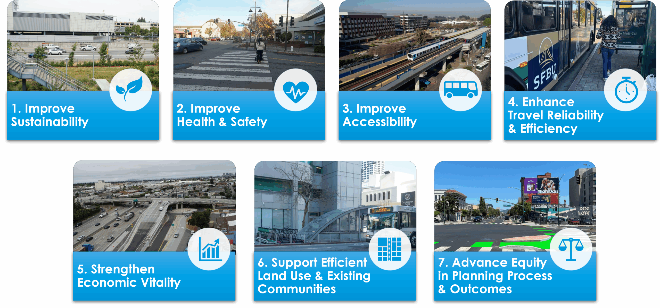
Key Plan Goals
The Plan is built around seven core goals, aligned with county, regional, and state transportation priorities:
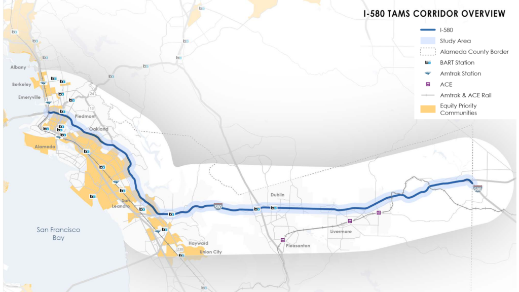
I-580 Corridor Study Area Map
(Click the map to view a larger version.)
Corridor Study Area
The “corridor" includes the interstate together with the transit services that serve the same travel pattern as the freeway, the bicycle and pedestrian facilities that connect to and through the corridor, and the adjacent neighborhoods and business districts that rely on and may be affected by changes in the corridor. The “study area” is a buffer of a half-mile on either side of the freeway right-of-way and select rail stations immediately adjacent to the freeway. This planning effort will evaluate conditions along the corridor and within the study area.Needs Assessment Findings
- Travel Demand & Congestion: High traffic volumes, particularly in the Tri-Valley and Oakland areas, lead to heavy congestion and unreliable travel times.
- Barriers to Safe Walking & Bicycling: I-580 creates obstacles for pedestrians and cyclists due to limited and disconnected crossing facilities
- Transit Accessibility & Efficiency: Transit use is hindered by long travel times, service gaps, and limited access to BART and ACE stations.
- Climate & Environmental Concerns: The consequences of climate change are expected to produce more extreme environmental conditions in the corridor, and climate hazards threaten both the physical assets of the I-580 corridor and neighboring communities.
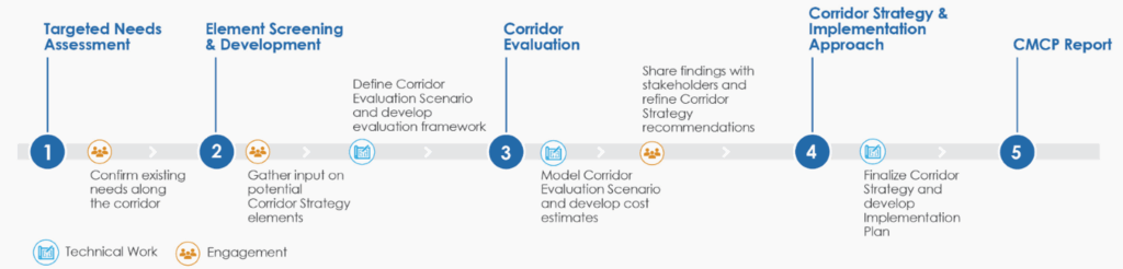
Corridor Strategy and Implementation Approach
Based on the evaluation results and feedback from CBO partners and agency stakeholders, elements of the final Corridor Strategy were identified either as near- or medium-term investments recommended for immediate advancement towards implementation or as long-term investments recommended for additional study and refinement prior to implementation. Recommended near- and medium-term investments are listed below:Near-Term Projects
- Expansion of the Countywide Bikeways Network (CBN) & Multi-Use Trails
- Transit priority infrastructure & multimodal corridor enhancements
- Rail station access and service improvements (e.g. BART and ACE)
- Safety improvements at key interchanges (e.g. I-580/ I-680)
- Technology enhancements to connect arterials with freeways for connected and autonomous vehicles
Medium-Term Projects
- Further implementation of multimodal corridors and trail projects
- Lower-priority connections between I-580 crossings and the CBN
- Further safety improvements at priority interchanges
- Valley Link Initial Operating Phase – Connecting the San Joaquin Valley to BART
Concepts Recommended for Long-Term Study
Recommended long-term investments in the Corridor Strategy consist of projects that require additional study and refinement related to impacts to freeway operations, cost effectiveness, and equity benefits prior to moving forward with implementation. To read detailed recommendations please see the I-580 TAMS plan here. A detailed technical evaluation memo for the I-580 TAMS can be downloaded here.
Community and stakeholder input was gathered through a mix of in person activities in the I-580 corridor study area, virtual and in person meetings with stakeholders, and online public engagement activities. This included the following:
- Five meetings with key businesses and institutions
- Three focus groups with Community-Based Organizations (CBOs)
- Three pop-up events
- An interactive, online web map
- A series of regular meetings with the TAC, the project management team (PMT), Oakland DOT, AC Transit, and BART
Engagement consisted of three phases:
- confirming existing transportation needs and challenges on and along the corridor;
- gathering input on draft Corridor Strategy elements; and
- refining the strategy, recommendations, and implementation priorities.
I-580 is one of the most heavily-traveled freeways in Alameda County, carrying significant intra-county traffic as it serves East, Central, and North county. Alameda CTC has made significant investments in and improvements along I-580 over the past two decades, including the construction and operation of the I-580 express lanes in the Tri-Valley.
The I-580 TAMS builds upon the following assessments and plans: